Phase I and Phase II Archaeological Investigations of the Richmond Hill Development, Williamsburg, Virginia
Colonial Williamsburg Foundation Library Research Report Series - 0394
Colonial Williamsburg Foundation Library
Williamsburg, Virginia
2009
Phase I and Phase II Archaeological Investigations of the Richmond Hill Development, Williamsburg, Virginia
Submitted to:
Mr. Roy B. Amason
8116 River Road
Richmond, Virginia
23229
Principal Investigator
Marley R. Brown III
Colonial Williamsburg Foundation
Department of Archaeological Research
February 1995
Re-issued
April 2001
Management Summary
In December of 1994, the Colonial Williamsburg Foundation conducted a Phase I archaeological evaluation of the proposed Richmond Hill housing development located at the corner of South Henry Street and Hunting Cove Road in Williamsburg. The 7.94 acre tract of land represents one of the last undeveloped pieces of property located in an area of known colonial settlement along the road to College Landing. The Phase I archaeological survey detected two discrete eighteenth century artifact concentrations on the property, leading to the recommendation that further testing be conducted to ascertain the existence of any colonial period structures associated with the artifacts.
With the support of developer Roy B. Amason, a Phase II archaeological evaluation was conducted on the Richmond Hill property during the second and third weeks of January, 1995. A series of machine trenches were excavated in the vicinity of the artifact concentrations in the hope of defining structural postholes or other related features. No related features were revealed through the testing, nor were any additional cultural resources identified. Therefore, no further archaeological work is required.
| Page | |
| Management Summary | i |
| List of Figures | iii |
| Introduction | 1 |
| Description of Project Area | 1 |
| Environmental Setting | 3 |
| Physical Description | 4 |
| Settlement History | 5 |
| Prehistorc Occupations | 5 |
| Historical Background | 5 |
| Previous Archaeological Research | 11 |
| Phase I Survey | 14 |
| Survey Method | 14 |
| Survey Results | 14 |
| Recommendation | 20 |
| Phase II Survey | 21 |
| Survey Method | 21 |
| Survey Results | 21 |
| Summary and Recommendations | 23 |
| References | 24 |
| Appendix 1. Artifact Inventory | 26 |
| Page | |
| Figure 1. Williamsburg, Virginia | 2 |
| Figure 2. Project area | 2 |
| Figure 3. Richmond Hill development plan | 3 |
| Figure 4. Theodorick Bland Map (1699) | 7 |
| Figure 5. Berthier map (1781) | 7 |
| Figure 6. Desandrouin's map (1781) | 8 |
| Figure 7. Matthew Davenport plat (1774) | 9 |
| Figure 8. Location of proposed canal (1818) | 10 |
| Figure 9. Phase I test units | 15 |
| Figure 10. Typical soil profile | 15 |
| Figure 11. Distribution of all artifacts | 16 |
| Figure 12. Distribution of architectural artifacts | 17 |
| Figure 13. Distribution of coal and slag | 18 |
| Figure 14. Location of phase II test trenches | 21 |
Introduction
In December of 1994, the Colonial Williamsburg Foundation Department of Archaeological Research (DAR) conducted a Phase I archaeological evaluation of the proposed Richmond Hill housing development located at the corner of South Henry Street and Hunting Cove Road in Williamsburg. The Richmond Hill property consists of a 7.94 acre parcel divided into fourteen individual lots. The probability of uncovering significant archaeological resources on the property was high, as the site is located in an area of known colonial settlement centered around the eighteenth century port at College Landing. Archaeological investigations in the vicinity during the 1970s and 1980s had located a number of eighteenth-century sites, as well as one mid seventeenth century domestic complex and evidence of prehistoric use of the terraces and stream channels in the College Landing area. During the Phase I archaeological survey at Richmond Hill, two concentrations of late eighteenth century artifacts were noted. Phase II archaeological investigations of these concentrations was recommended in order to ascertain the existence of any structures or features associated with the artifacts.
Phase II investigations were then carried out at the Richmond Hill site in January of 1995, with approval and funding from developer Roy B. Amason. The method used during the Phase II investigation consisted predominately of machine stripping in the areas of high artifact density, in the hopes of unearthing intact features or related structural remains. The results of the machine stripping indicated that if any eighteenth century structures had once existed on the property, their archaeological traces had been eradicated, possibly through the plowing activity which had occurred throughout the Richmond Hill property.
Marley R. Brown III, director of the DAR, and Staff Archaeologist David Muraca provided general supervision of the Phase I and Phase II investigations at Richmond Hill. Field Supervisor Dwayne Pickett led a field crew which included Christina Adinolfi and Jenna Thompson on the Phase I survey. Laboratory Technician Susan Wiard processed and catalogued all artifacts, which are presently stored at the DAR. Dwayne Pickett and Project Archaeologist Audrey Horning performed the Phase II survey with the expert assistance of Charlie Green of Dudley Waltrip and Sons, Inc. Graphics for the report were drafted by Audrey Horning, David Muraca, and Christina Adinolfi. The report itself was prepared by Audrey Horning.
Description of Project Area
Location
The 7.94 acre tract of land slated for development as the Richmond Hill subdivision is located within the city of Williamsburg, Virginia at the corner of South Henry Street and Hunting Cove Road, opposite the Cedar Grove Cemetery (Figures 1 and 2). The site area is located less than one mile from the restored eighteenth century town of Williamsburg, and is itself located in an area of known colonial settlement centered upon the port of College Landing. Just beyond the site area, on the opposite side of South Henry Street, is the Marshall Wythe School of Law and the College of William & Mary Graduate Housing
2
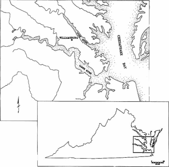 Figure 1. Williamsburg, Virginia.
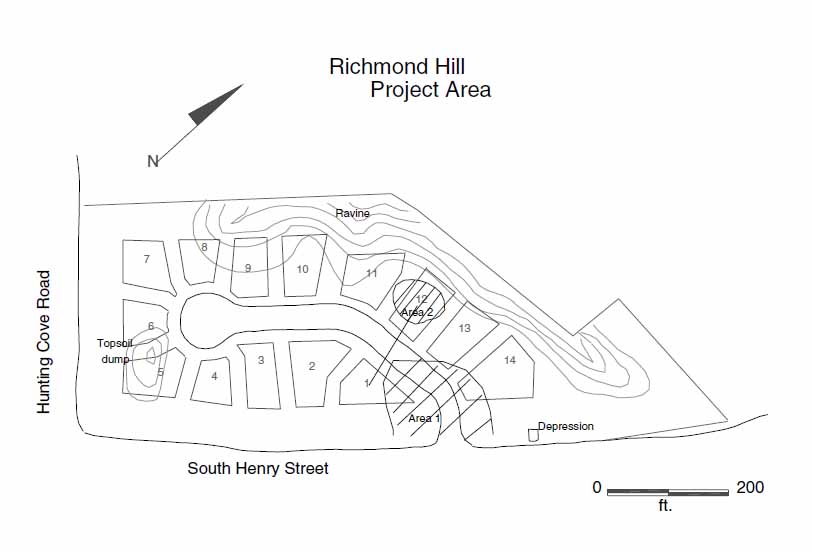 Figure 2. Location of project area.
3
Complex. Development exists on all sides of the proposed Richmond Hill subdivision, including the Coves to the south and west, and beyond that the Port Anne subdivision (Figure 3). A neighborhood dating to the early twentieth century lies directly northeast of the Richmond Hill property, along Mimosa Street. The proposed Richmond Hill development will consist of 14 single family homes placed on lots averaging 10,000 square feet, clustered along one road with a culdesac.
Figure 2. Location of project area.
3
Complex. Development exists on all sides of the proposed Richmond Hill subdivision, including the Coves to the south and west, and beyond that the Port Anne subdivision (Figure 3). A neighborhood dating to the early twentieth century lies directly northeast of the Richmond Hill property, along Mimosa Street. The proposed Richmond Hill development will consist of 14 single family homes placed on lots averaging 10,000 square feet, clustered along one road with a culdesac.
Environmental Setting
The Richmond Hill property is located on the lower portion of the James-York peninsula, which lays within the physiographic region known as the Atlantic Coastal Plain just at the transition between the Inner and Outer plain. The climate in this area is relatively mild, with yearly temperatures averaging 59.1 degrees Fahrenheit. The terrain in the Williamsburg vicinity is characterized by finger ridges and broad terraces which are cut and drained by a number of ravines which empty into College Creek and Queen's Creek. These two waterways drain into the James and York Rivers, respectively. Topography in the region is fairly gentle, with the only exception being the occasionally steep sided ravines and stream channels. The well drained soils in the region are part of the Emporia series which are "formed in stratified loamy and clayey fluvial and marine sediments" (Hodges et al. 1985) and are well suited to agricultural activity (Johnson et al. 1981).
The Richmond Hill parcel is situated on a ridge, not far from College Creek. In addition to providing drainage for the surrounding uplands, College Creek, originally designated Archer's Hope Creek, was also the location of an important eighteenth century
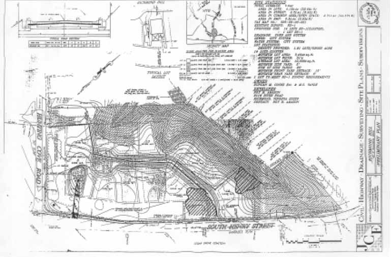 Figure 3. Richmond Hill development plan.
4
landing. The waterway itself is slow moving and shallow, measuring less than ten feet in depth at the site of the landing itself (Brown 1986a).
Figure 3. Richmond Hill development plan.
4
landing. The waterway itself is slow moving and shallow, measuring less than ten feet in depth at the site of the landing itself (Brown 1986a).
Physical Description
A steep sided ravine cuts along the northern and western boundaries of the project area, but the remaining land on the Richmond Hill property is part of a relatively flat terrace which exhibits less than a ten percent slope. The ravine itself does not support a permanent stream, rather it serves as drainage for the surrounding ridges, eventually emptying into College Creek. The channel is filled with cultural debris dating from the late nineteenth through the twentieth century, indicating its use as a convenient dump site for household refuse originating from thecommunity on Mimosa Street. The overall site area is covered predominantly with twenty to thirty year old loblolly pines, which have been severely impacted by Virginia Creeper and Poison Ivy vines. The area apparently served as pasture land prior to the growth of the pines, according to machine operator and long time local resident Charlie Green. Soil profiles indicate that the site was also clearly plowed into at least the early twentieth century. One feature readily observeable in the project area is an area of stockpiled topsoil approximately fifty feet wide and 150 feet in length close to Hunting Cove Road. The topsoil pile presumably relates to previous construction activity at the Coves.
Settlement History
Prehistoric Occupations
The eastern portion of Virginia was first occupied by Native American groups close to 12,000 years ago. Between approximately 9500 B.C. and 6500 B.C, prehistoric groups focused predominately upon the hunting of large game as a subsistence strategy. The continual mobility required by such a lifestyle has ensured that few archaeological sites dating to this period, which encompasses part of the Paleolithic and early Archaic periods in a classifactory scheme based upon tool types, are detectable. The presence of finely made, fluted projectile points known as Clovis and Fulsom, is often the only trace found indicating the presence of these early hunting groups. Between 6500 B.C. and 2000 B.C., the climate had warmed significantly, resulting in the appearance of more abundant plant and animal species. Within the Tidewater area, the estuarine environment had begun stabilizing, therefore providing an increasingly important and abundant food source. Sites dating to this period, encompassing the classification phase known as the Middle Archaic, tend to be seasonal base camps.
During the next three thousand years, including what has been delineated as the late Archaic and Early and Middle Woodland periods, sedentism increased through the growing reliance upon riverine and estuarine resources. Sites dating to this period are typically located on high ground adjacent to such resources. The development of ceramic technology occurred early in this more sedentary phase of prehistoric life in eastern Virginia. During the last 500 years prior to European contact with native groups in eastern Virginia, horticulture had become the basis of subsistence, and therefore settlements became larger and more permanent. Attendant sociopolitical systems likewise increased in complexity. Just prior to English settlement in the Virginia Tidewater, over thirty Algonquian speaking tribes in the Coastal Plain were organized into a chiefdom known to its members as Tsenacommacah, presided over by a paramount chief named Wahunsonacock who held the title of Powhatan. The tribes within the chiefdom each had one and sometimes several permanent villages situated along the major rivers, including the James, York, Chickahominy, Mattaponi, Pamunkey and Rappahannock, as well as along smaller tributaries.
Historical Background
During the seventeenth century, the Richmond Hill property was contained within the bounds of Middle Plantation, which was itself loosely defined by an Act of Assembly in 1622/3 as all the land "betweene Queenes creeke in Charles river (present York River), and Archers Hope creek (present College Creek) in James river, with all the lands included, to the bay of Chesapiake" (Hening 1809-1823: III: 342) . During the 1630s, a six mile palisade was constructed in Middle Plantation between Archer's Hope and Queen's Creeks, more as a psychological barrier than an actual impediment to native incursions. The palisade itself had to be replaced in 1646, perhaps as a result of an uprising two years before which had been led by the present Powhatan, Opecancannough, brother to Wahunsonacock.
6The settlement of Middle Plantation grew slowly but steadily throughout the seventeenth century, and in 1683, it acquired its own church, Bruton Parish. Ten years later, the College of William & Mary was established, not in the capitol of Jamestown, but at Middle Plantation. Following a devastating fire in Jamestown in 1698, the capitol was transferred to Middle Plantation, which was then renamed Williamsburg. The Act which established Williamsburg also established two ports for the capitol town. One port was created on Queen's Creek, leading into the York River, and was named Queen Mary's Port (present Capitol Landing). Two miles to the southwest, not far from the present Richmond Hill property, Princess Anne's port (now College Landing) was established on Archer's Hope Creek (Figure 4). A road led to the port from the town of Williamsburg which passed near the Richmond Hill property.The Act which established the port likewise stated that "a sufficient quantity of land at each port or landing shall be left in common" but lots "that shall not exceed sixty foot square" could be laid out (Hening 1809-1823: III: 432; McCartney 1976: 1).
The College Landing port appears to have been immediately active, with a ferry established in 1705 which provided transport to Hog Island four miles away. In the 1730s, the landing was designated a tobacco inspection station, which required the construction of "a good substantial warehouse or warehouses… and a good wharf at a landing adjoining thereto." While the Capitol Landing port was also designated a tobacco inspection station, it ceased to function in that capacity in 1783, with the College Landing site taking over the entire flow of tobacco (McCartney 1976: 2-5).
A number of other commercial activities took place at College Landing during the eighteenth century. Furniture and carriage maker Charles Taliaferro constructed a warehouse at College Landing in 1775, marketing both his wares and storage space at the site. Taliaferro additionally posted his overseer in a dwelling at the Landing. Four years later, Taliaferro was also operating a brewhouse at College Landing (Brown 1986a: 9; Dixon 1775; McCartney 1976).
Ships bound for New England, the West Indies, and Great Britain called at the College Landing port, as it was renamed by the time of the Revolution. In addition to loading tobacco and other goods at the site, ships often marketed imports at the Landing. A French schooner in 1778 sold nails, cordage and brandy at the port. A year later, Muscavado sugar and French rum were marketed at College Landing. During the Revolution, College Landing served as a military provisionment site. Three French military maps were produced of the area in 1781—the Desandrouins Map, the Berthier Map, and the St. Simon Map. These maps indicate the presence of at least six structures at the landing itself (Figures 5 and 6; Brown 1986a: 9-13).
Numerous advertisements in the Virginia Gazette indicate that human traffic down the College Landing Road to the landing, passing the Richmond Hill site, was heavy and constant. A number of horses were lost at the site, including William Norvell's "Small Grey Horse" which strayed from College Landing on August 12, 1745 (Parks 1745). Benjamin Bryan's 1763 advertisement for a runaway slave named Sarah seen at College Landing serves as a reminder of an altogether different sort of human traffic flowing through College Landing and down the road past the present day Richmond Hill property (Hunter
7
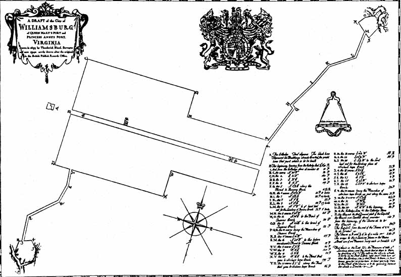 Figure 4 . Theodorick Bland plat (1699).
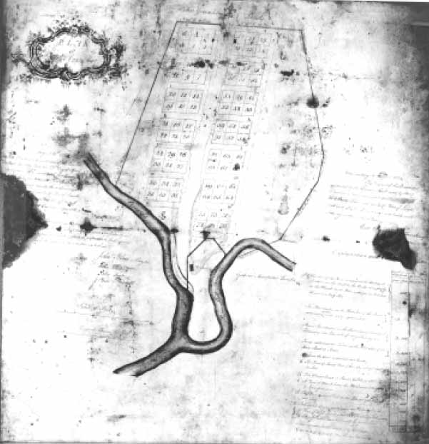 Figure 5. Matthew Davenport plat (1774).
8
Figure 5. Matthew Davenport plat (1774).
8
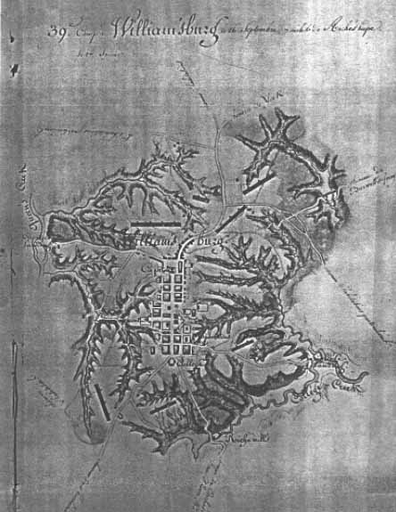 Figure 6. Berthier Map (1781).
1763). Certainly the traffic through the port would have provided numerous opportunities for escape.
Figure 6. Berthier Map (1781).
1763). Certainly the traffic through the port would have provided numerous opportunities for escape.
That a considerable amount of development had taken place at College Landing by the third quarter of the eighteenth century is certain, as depicted in a survey of the port compiled in 1774 by Williamsburg town clerk Matthew Davenport (Figure 7). On the plat, Davenport depicted a regular street plan consisting of 78 lots separated by eight
9
 Figure 7. Desandrouin's Map (1781).
cross streets. Five structures were specifically delineated on Davenport's plat, including one clearly labelled as a warehouse on property which belonged to Williamsburg merchant John Greenhow.
Figure 7. Desandrouin's Map (1781).
cross streets. Five structures were specifically delineated on Davenport's plat, including one clearly labelled as a warehouse on property which belonged to Williamsburg merchant John Greenhow.
Following the transfer of Virginia's capital from Williamsburg to Richmond, "College Landing seems to have declined in importance and slipped into relative obscurity" (McCartney 1976: 21)
. The site was not abandoned, however. Efforts to construct a canal from College Landing to Williamsburg were proposed by the Virginia Canal Company in 1818, although the attempt never progressed beyond the planning stage (Figure 8). A plat for the proposed canal, surveyed and produced by Thomas Ladd, provides valuable information on land ownership in the vicinity of College Landing. Ladd's plat indicates that the Richmond Hill property was then in the hands of the Tazewell family, who transferred their property on the west side of College Landing Road to a Dickie Galt in 1839. The Civil War marked the end of College Landing's serving as an important port.
10
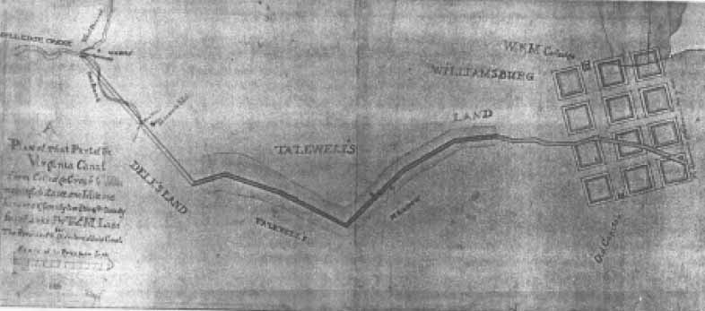 Figure 8. Map of proposed canal (1818).
Still navigable during the War, there is little mention of the port in succeeding years. The property along College Landing Road reverted to predominantly agricultural use, with the eastern side of the road employed by Eastern State Hospital as a farm. Archaeological evidence from the Richmond Hill property indicates that it supported agricultural activity through much of the nineteenth and twentieth centuries.
Figure 8. Map of proposed canal (1818).
Still navigable during the War, there is little mention of the port in succeeding years. The property along College Landing Road reverted to predominantly agricultural use, with the eastern side of the road employed by Eastern State Hospital as a farm. Archaeological evidence from the Richmond Hill property indicates that it supported agricultural activity through much of the nineteenth and twentieth centuries.
Previous Archaeological Research
The considerable degree of development which has taken place along South Henry Street during the past two decades has resulted in the investigation of a number of historic sites close to the Richmond Hill property, the majority of which have been associated with College Landing (44WB 3), which is on the National Register of Historic Places.
Prior to the 1976 extension of South Henry Street across Paper Mill Creek to the intersection with Route 199, archaeological investigations were carried out by the Virginia Research Center for Archaeology under the direction of Carter Hudgins. The survey resulted in the identification of three structures in the College Landing area noted on the Davenport Plat of 1774: an apparent well, a probable warehouse at the base of the landing, and an artifact scatter on the western ridge above the landing. Two sites within the right-of-way of the South Henry Street extension were slated for excavation. These sites included a small domestic structure located on Lot 37 of the Davenport plat, and the presumed well, sited between lots 92 and 93 on the aforementioned plat. Excavations again led by Carter Hudgins took place in 1976. The dwelling was interpreted as a one and a half story structure with a brick cellar, dating to the period ca. 1750-1815. Near this building an associated well, filled during the early 1770s, was discovered. (Hudgins 1977; Brown 1986a)
In the vicinty of the presumed well between Davenport lots 92 and 93, Hudgins uncovered a complex of features dating to the early eighteenth century. The features included a partial cellar, associated root cellar and chimney base, a series of drainage ditches, and a refuse pit. Additionally, an 1.9 foot deep trench was uncovered that was apparently used in some type of craft activity. A late nineteenth century filled cellar hole was also uncovered which was associated with a pumping station for Eastern State Hospital. This feature had been idenified as the aforementioned well in the Phase I investigation. The most significant archaeological remains uncovered in this 1976 investigation was a late eighteenth-early nineteenth century cemetery containing the remains of twenty individuals, all African-American. The burials were each excavated, as they lay within the proposed right-of-way (Hudgins 1977; Brown 1986a).
In December of 1985, another archaeological survey of the College Landing area was undertaken. The Office of Archaeological Excavation of the Colonial Williamsburg Foundation performed a two week investigation of the National Register site of College Landing at the behest of the City of Williamsburg, surveying property owned by the City as well as by the College of William & Mary. While no significant sites were located on the College of William & Mary owned property on the western side of South Henry Street, owing primarily to twentieth century disturbances, several historic sites were located on the City owned portion which encompasses the landing site itself. A probable eighteenth century warehouse was identified which may be the Greenhow warehouse identified on the Davenport plat, or alternatively may be Taliaferro's warehouse of 1775. Other features identified on the City owned property included two corduroy roads and at least 28 wharf pilings, all evident at low tide. On the College property, only an abandoned twentieth- 12 century logging road and late nineteenth-early twentieth century refuse dump were identified. (Brown 1986a).
Another archaeological investigation by Colonial Williamsburg during 1986 and 1987 close to the Richmond Hill site resulted in the identification of seven archaeological sites within the property being developed as the Port Anne subdivision. Of the seven sites located on the property, five dated to the eighteenth century, and were associated with College Landing. One site was prehistoric, and another formed part of an early seventeenth century domestic complex. This early seventeenth-century site, which also included a graveyard, was subsequently excavated.
Eighteenth-century features identified within the Port Anne development included one obvious dwelling, thought to be home of John Jordan, warehouse overseer for Charles Taliaferro. The site consisted of a brick chimney base, cellar hole, partial foundation, and a series of posthole features. Artifacts dated the site to the last quarter of the eighteenth century. Another presumed domestic site was represented by a scatter of late eighteenth century artifacts, and three ditches. The Matthew Davenport plat indicated that a structure was indeed located in the vicinity, even though no structural evidence was uncovered during the archaeological investigation. A third eighteenth century site included a large feature filled with storage and serving vessels which was interpreted as a cellar, possibly for a tavern or for the residence of John Roan, known to have served as ferry keeper in 1774. Two scatters of eighteenth century domestic debris without any associated structural remains or other cultural features were also located by the survey on the Port Anne property (Brown 1986b).
The one prehistoric site located in the survey of the Port Anne property was situated on a terrace above a stream, and was represented by the presence of fire cracked rock, and a total of four pieces of pottery. Two of the ceramic fragments were shell tempered, dating to the Late Woodland period (1000-1600 A.D.), and the other two sherds were sand and pebble tempered, dating to the Middle Woodland period (500 B.C.-1000 A.D.). No associated features, such as shell middens, were identified, nor was there evidence for intact cultural layers (Brown 1986b).
The most significant and most threatened site discovered in the Phase I and Phase II investigations on the Port Anne property was the seventeenth century domestic site and graveyard, which was uncovered as developers were constructing the road now known as Hague Close. The site was occupied over a twenty to forty year period during the mid seventeenth century. Machine stripping of the site area revealed a total of eight graves, three trash pits, the traces of several fencelines, and a large, irregularly shaped borrow pit. Structural evidence from the site included numerous postholes, and traces of a hearth, suggesting a domestic complex which included a dwelling and at least two outbuildings. The property originally formed part of the holdings of Dr. John Pott, who served as colonial Governor in 1639. During the 1620s, Pott controlled approximately 1,700 acres within Middle Plantation. In the 1630s, however, Pott had sold the property in the present Port Anne development to either a Richard Brewster, or a William Davis (Edwards 1987: 40-43; Brown 1986b: 13-16).
13In view of the considerable amount of historic activity that took place in the vicinity of the Richmomd Hill property as revealed by archaeological and documentary examinations of the College Landing area, coupled with the environmental suitability of the location for prehistoric use, it was imperative that the Richmond Hill tract be completely surveyed. As the only remaining undeveloped property near College Landing, Richmond Hill had the potential to provide the last source of new evidence on prehistoric and historic settlement near the National Register site.
Phase I Survey
Survey Method
The Phase I archaeological survey of the proposed Richmond Hill development consisted of a pedestrian survey over the project area in combination with systematic shovel testing (Figures 9 and 10). During the two day survey in December of 1994, 52 test units measuring 50 by 50 cm were excavated across the 7.94 acre parcel. Test units were placed at ten meter increments throughout the tract, with additional units excavated at five meter increments around units which yielded high concentrations of artifacts. All test units were excavated to the level of sterile subsoil, generally encountered at 25-30 centimeters below the ground surface. Areas exhibiting greater than a twenty percent slope were not tested.
All soil excavated from the test units was screened through ¼-inch mesh to ensure recovery of all artifactual materials. Each test unit, including those that were negative, was assigned a context number and was recorded individually. Recovered artifacts were retained and taken to the DAR facilities where they were washed, identified, and catalogued with all information entered into the Rediscovery computer database.
Survey Results
Artifacts recovered from the Phase I testing consisted predominantly of late eighteenth century domestic artifacts including ceramic sherds, bottle glass fragments, tobacco pipestems, nails, and small pieces of brick. All artifacts were found in the layer of plow disturbed soil which extended from immediately below the topsoil to the level of subsoil. No structural evidence was uncovered during this survey. In addition, no evidence was uncovered pertaining to prehistoric activity in the project area, even though the combination of a flat terrace with a stream bed present at Richmond Hill often appealed to prehistoric populations.
Examination of computer generated maps plotting the distribution of recovered artifacts across the site area highlighted two areas of artifact concentration (Figures 11 to 13). One area was located in the northern portion of proposed lot 14, and corresponded to a single test unit, context 58AI-6. This test unit was terminated at a depth of 65 centimeters as subsoil had not yet been reached. The test unit contained a concentration of eighteenth century artifacts including white salt glazed stoneware, dating to the 1740s and pearlware, which was first produced in 1779 but was available until the 1830s. Surrounding test units reached subsoil within 30 centimeters, and contained only a small percentage of artifacts, suggesting that test unit 58AI-6 had been placed directly into either a deep cultural feature, or a filled ravine.
A more significant and dense concentration of late eighteenth-century artifacts was encountered within an area encompassing portions of lots 1 and 2 along with the proposed roadway. Within this area, shovel test units were excavated at 5-meter intervals. While no
15
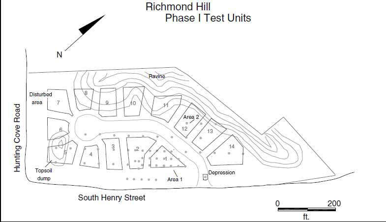 Figure 9. Location of phase I test units.
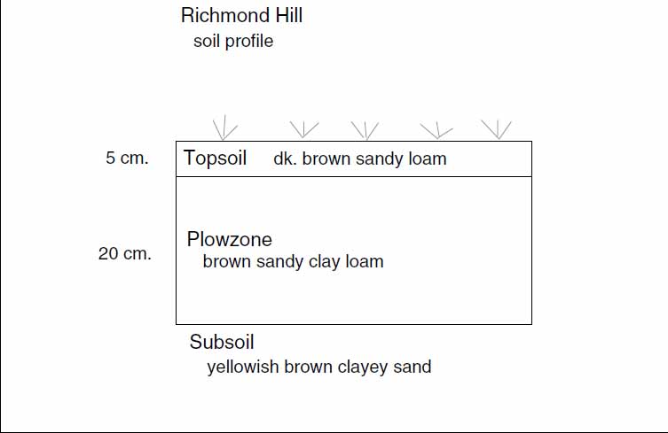 Figure 10. Typical soil profile.
16
Figure 10. Typical soil profile.
16
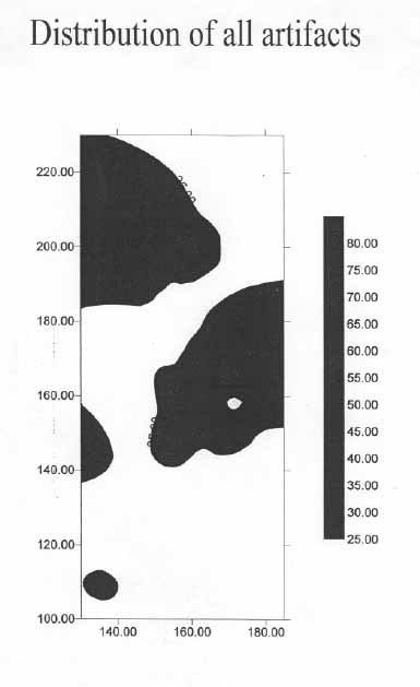 Figure 11. Distribution of all artifacts.
17
Figure 11. Distribution of all artifacts.
17
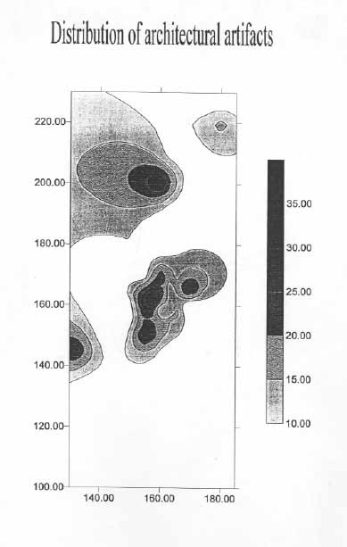 Figure 12. Distribution of architectural artifacts.
18
Figure 12. Distribution of architectural artifacts.
18
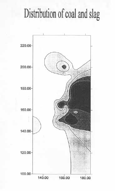 Figure 13. Distribution of coal and slag.
19
evidence for an associated structure was noted during the testing of this area, the possibility of a colonial period structure existing in corollation with the high artifact concentration was strong. Test units in the area produced from twenty to over one hundred artifacts apiece, all dating to the late eighteenth and early nineteenth centuries. The sole exception was found in test unit 58AI-43, which produced one fragment of manganese solarized glass, which dates after 1880. Forty-eight other artifacts were found in this unit, including seven ceramic sherds which all fell into the late eighteenth-early nineteenth century date range.
Figure 13. Distribution of coal and slag.
19
evidence for an associated structure was noted during the testing of this area, the possibility of a colonial period structure existing in corollation with the high artifact concentration was strong. Test units in the area produced from twenty to over one hundred artifacts apiece, all dating to the late eighteenth and early nineteenth centuries. The sole exception was found in test unit 58AI-43, which produced one fragment of manganese solarized glass, which dates after 1880. Forty-eight other artifacts were found in this unit, including seven ceramic sherds which all fell into the late eighteenth-early nineteenth century date range.
Analysis of ceramic types found in test units within the area of high artifact density revealed that a full 39% were creamware, a refined earthenware produced by Josiah Wedgwood from 1760 into the 1780s. Eighteen percent of the sherds were pearlware fragments, which was Wedgwood's successor to the popular creamware, produced from 1779 into the 1830s. Another eight percent of the sherds were refined earthenwares which could not be precisely identified, but were either creamware or pearlware. The earliest dateable ceramic recovered from the test units was white saltglazed stoneware, represented by two sherds. White salt glazed stoneware was produced during the 1740s. The latest ceramic recovered in the area of high artifact density was a single fragment of yellow ware, produced after 1830. The fact that refined earthenwares accounted for 66% of recovered ceramics indicates a domestic origin, as refined wares generally produced only in the form of tablewares (Noël Hume 1969: 125-132).
One of the most useful dating tools for archaeologists examining colonial period sites is the imported tobacco pipe, ubiquitous on the majority of seventeenth and eighteenth century sites (Harrington 1954). Archaeologist Jean C. Harrington, while working at Jamestown in the 1930s and 1940s, discovered that the diameter of the bore hole in the stem decreased over time in a regular fashion. Measuring the bores with standard 64th inch drill bits allows for the rapid dating of an archaeological context, provided a reasonable sample number exists to account for individual variation. Only two measurable pipestem fragments were recovered from test units in the area of artifact density at Richmond Hill, however. Both were found in test unit 58AI-46. The bore diameter for one of the pipes measured 4/64s inch, while the other measured 5/64s inch. The 5/64 inch pipestem, according to Harrington's mean date system, dates to the period 1710-1750, while the 4/64 inch pipestem dates to the period 1750-1800. While two pipestems do not constitue a meaningful sample by any stretch of the imagination, their dates do agree with the ceramic evidence.
The artifacts recovered from the area of concentration in the vicinity of proposed lots 1, 2 and the roadway all point to the presence of a domestic site dating roughly from 1750 to the 1830s. The time frame correlates with the greatest activity at the College Landing port. Only a negligible amount of brick debris was recovered during the Phase I survey, indicating that the predicted structure would have been of earthfast construction. Earthfast structures rely upon integral framing posts set in the ground which support a predominantly wooden structure. Post in ground structures are often difficult to identify during Phase I assessments, however, because the only archaeological traces of the actual structure consist of soils stains in the location of the structural posthole.
Recommendation
Following the Phase I survey of the Richmond Hill property, developer Roy B. Amason was advised by the Colonial Williamsburg Foundation Department of Archaeological Research of the necessity of further archaeological testing on the property in order to ascertain whether evidence for one or more earthfast structures existed in the proposed subdivision.
Phase II Survey
Survey Method
The aim of the Phase II archaeological evaluation of the Richmond Hill property was to determine if any structural remains or other archaeological features existed within the areas predicted by the distributional analysis of artifacts recovered during the Phase I survey. As discussed, the paucity of brick recovered during the December survey indicated that, if a structure existed at all on the Richmond Hill lot, it would be of earthfast construction. The most expedient method of ascertaining the existence of posthole features at Richmond Hill was machine stripping down to the level of subsoil.
Seven machine trenches approximately two meters in width by twenty meters in length, and 30-40 centimeters in depth, were excavated to the level of sterile subsoil (Figure 14). A smooth bucket backhoe was employed. Six trenches were located in the vicinity of the densest concentration of artifacts, while the seventh trench was excavated over test unit 58AI -6, which had yielded a large quantity of artifacts in combination with deep stratigraphy. Following the machine excavation, the surface of the subsoil in each trench was manually cleaned and carefully examined in order to locate intact cultural features. In addition to the machine trenching, three additional 50 × 50 cm test units were excavated and all soil from these test units was screened through one quarter inch mesh.
Survey Results
One machine trench was excavated over the location of the Phase I test unit in the northern portion of Lot 12 which exhibited a high concentration of artifacts in combination with
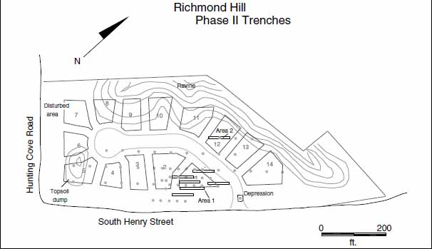 Figure 14. Location of phase II test trenches.
22
deep stratigraphy. The trench revealed the expected existence of a natural gully which gradually descended to a depth of approximately 95 centimeters where the test unit was located. No cultural features were observed in the subsoil below the fill of the gully. Presumably this gully served as a convenient disposal site, accounting for the artifacts encountered during the Phase I testing. Artifacts from this test unit were identical to the types recovered from the area of high artifact density in lots 1, 2, and the roadway again suggesting the existence of a domestic site on the Richmond Hill property dating to the second half of the eighteenth century through the first quarter of the nineteenth century. The cultural material deposited in the gully uncovered by test unit 58AI-6 and the machine trench must have originated from a nearby domestic site. To the northeast of the sloping gully, the machine trench revealed an extensive deposit of pinkish clay. Testing revealed no artifacts or features in association with this clay, which appears to be a geologic rather than a cultural phenomenon.
Figure 14. Location of phase II test trenches.
22
deep stratigraphy. The trench revealed the expected existence of a natural gully which gradually descended to a depth of approximately 95 centimeters where the test unit was located. No cultural features were observed in the subsoil below the fill of the gully. Presumably this gully served as a convenient disposal site, accounting for the artifacts encountered during the Phase I testing. Artifacts from this test unit were identical to the types recovered from the area of high artifact density in lots 1, 2, and the roadway again suggesting the existence of a domestic site on the Richmond Hill property dating to the second half of the eighteenth century through the first quarter of the nineteenth century. The cultural material deposited in the gully uncovered by test unit 58AI-6 and the machine trench must have originated from a nearby domestic site. To the northeast of the sloping gully, the machine trench revealed an extensive deposit of pinkish clay. Testing revealed no artifacts or features in association with this clay, which appears to be a geologic rather than a cultural phenomenon.
Machine stripping in the vicinity of lots 1, 2, and the proposed roadway provided coverage both in and around the location of the highest artifact density, and the predicted location of an associated structure. Cleaning and examination of the subsoil in the six machine trenches revealed no conclusive evidence of a structure, however. Features revealed by the stripping included only two modern circular post stains, probably from a fence line; several tree holes, and one potential posthole feature. This possible posthole was mapped and recorded, but continued stripping did not uncover any associated features to indicate the feature's relation to any structure. No evidence for a structure associated with the concentration of eighteenth century artifacts was found. Subsequent agricultural activity over the site may have eliminated all evidence of a structure, as deep plowing could destroy shallow posthole features. Or, the structure may not have employed postholes at all, instead being constructed upon ground laid sills or brick piers, which would leave little trace below the ground surface. Alternatively, of course, there may never have been any dwelling on the Richmond Hill property. The presence of the artifact concentrations and their domestic composition, however, makes the latter scenario unlikely.
Three additional test units were excavated during the Phase II survey. One unit was located in a rectangular depression noted in the earlier survey, which was located close to South Henry Street, just north of the primary area of high artifact concentration. The test unit revealed the depression to be a recent feature. Portions of a modern green glass bottle were located in the depression, and testing revealed that no deeper feature, such as a trash pit or cesspit, existed in the location. The other two test units were excavated on the terraced ridge above the ravine in lot 12 as an extension of the Phase I survey area primarily to make certain that no prehistoric resources were present. Both of these test units were negative. All three test units have been plotted on the accompanying site map.
All machine trenches and the three test units excavated during the Phase II investigation at Richmond Hill were backfilled on the last day of the investigation. No artifacts were generated during the Phase II survey. All documentation is on file at Colonial Williamsburg.
Summary and Recommendations
Archaeological investigations were carried out on the Richmond Hill property within the bounds of the City of Williamsburg by the Colonial Williamsburg Foundation Department of Archaeological Research, in cooperation with developer Roy B. Amason, during December of 1994 and January of 1995. Because the Richmond Hill tract is located in an area of known colonial activity, and because a number of archaeological sites have been investigated in close proximity to the property, the potential for uncovering significant cultural remains was high. A Phase I archaeological study of the property revelaed the existence of two concentrations of late eighteenth and early nineteenth century artifacts which suggested the existence of a domestic site of that period on the Richmond Hill property. Activity in the general area of College Landing was at a peak during the time of the Revolution and into the early part of the next century. Considerable traffic would have passed the Richmond Hill property on the College Landing Road as it flowed to and from the bustling port.
Although Phase I testing predicted the existence of a dwelling within the Richmond Hill property, Phase II testing employing machine clearing found no evidence for the survival of any archaeological site on the property. One explanation for the presence of domestic artifacts without any associated structural features is that a dwelling once existed on the property, but its construction may have been insubstantial enough as to leave no subsurface trace. The site area was subjected to heavy plowing, which distorts and often destroys subsurface archaeological features. Traces of brick found in plowzone may indicate that the predicted structure was built upon piers, which leave few subsurface scars. The possibility also exists that the domestic site associated with the artifact concentration was located outside of the survey area, in the vicinity of the Coves or obscured by the present day South Henry Street, and that the concentrations on the Richmond Hill lot were the result of dumping. Clearly, the filled gully detected in the archaeological survey served as a dumping ground for domestic refuse. Use of the gully for depositing refuse, however, increases the likelihood that the primary area of artifact density was associated with a structure rather than a dump site.
All evidence indicates that a domestic structure was present on the Richmond Hill property during the late eighteenth century into the nineteenth century. Our testing strategy of excavating machine trenches throughout the areas of high artifact concentration should have uncovered evidence of any significant cultural resources still extant on the property. Because no archaeological features were encountered during the Phase II investigation, despite the artifact concentrations, there is no reason to believe that significant cultural resources survive on the property. In light of the negative results of the Phase II investigation, there is no compelling justification for any further archaeological work to be carried out at Richmond Hill.
- 1986a
- Archaeological Investigations at the College Landing National Historic Site. Office of Archaeological Excavation, Colonial Williamsburg Foundation, Williamsburg, Virginia.
- 1986b
- Phase I and Phase II Archaeological Investigations of the Port Anne Development. Office of Archaeological Excavation, Colonial Williamsburg Foundation, Williamsburg, Virginia.
- 1774
- Plan of Princess Anne's Port. Copy on file, Foundation Library, Colonial Williamsburg Foundation, Williamsburg, Virginia.
- 1775
- Virginia Gazette, 3 June, 1775.
- 1987
- Phase III Archaeological Investigations at Port Anne. Office of Archaeological Excavation, Colonial Williamsburg Foundation, Williamsburg, Virginia.
- 1954
- "Dating Stem Fragments of Seventeenth and Eighteenth Century Clay Tobacco Pipes." Quarterly Bulletin of the Archaeological Society of Virginia 9, No.1.
- 1809-1823
- The Statutes at Large: Being a Collection of all the Laws of Virginia, from the First Session of the Legislature in the Year 1619. 13 volumes. Richmond: Samuel Pleasants.
- 1985
- Soil Survey of James City County and the City of Williamsburg, Virginia. United States Department of Agriculture, Soil Conservation Service, and the Virginia Polytechnic Institute and State University.
- 1977
- Historical Archaeology and Salvage Archaeological Excavations at College Landing: an Interim Report. Virginia Research Center for Archaeology.
- 1763
- Virginia Gazette, 4 November 1763.
- 1981
- Guidebook to the Late Cenozoic Geology and Economic Geology of the Lower James-York Peninsula, Virginia. Guidebook No. 3. Department of Geology, College of William and Mary, Williamsburg, Virginia.
- 1976
- A History of College Landing. Research Report 58, Foundation Library, Colonial Williamsburg Foundation. 25
- 1995
- The Aspirations, Ambience, and Actualities of Middle Plantation. Paper presented at the Society for Historical Archaeology Conference, Washington, DC.
- 1969
- A Guide to Artifacts of Colonial America. New York: Vintage Books.
- 1745
- Virginia Gazette, 19 September 1745.
References
Appendix 1. Aritfact Inventory
Note: Inventory is printed from the Re:discovery cataloguing program used by Colonial Williamsburg, manufactured and sold by Re:discovery Software, Charlottesville, Virginia.
Brief explanation of terms:
- Context No. Arbitrary designation for a particular deposit (layer or feature), consisting of a four-digit "site/area" designation and a five-digit context designation. The site/areas for this project are "58AI" (Phase I) and "58AJ" (Phase II). Note that no artifacts from 58AJ were recovered.
- TPQ "Date after which" the layer or feature was deposited, based on the artifact with the latest initial manufacture date. Deposits without a diagnostic artifact have the designation "NDA," or no date available.
- Listing The individual artifact listing includes the catalog "line designation," followed by the number of fragments or pieces, followed by the description.
| AA | 1 | EARTHENWARE, DELFTWARE ENG, FRAGMENT, PAINTED UNDER, BLUE |
| AB | 1 | REFINED EARTHEN, CREAMWARE, FRAGMENT, UNDECORATED |
| AC | 1 | REFINED EARTHEN, PEARLWARE, FRAGMENT, PAINTED UNDER, BROWN |
| AD | 1 | STONEWARE, WH SALT-GLAZED, FRAGMENT |
| AE | 1 | SHELL, FRAGMENT |
| AF | 1 | BRICK, BRICKETAGE |
| AA | 1 | EARTHENWARE, DELFTWARE ENG, FRAGMENT, UNDECORATED |
| AB | 2 | REFINED EARTHEN, CREAMWARE, FRAGMENT, UNDECORATED |
| AC | 1 | COARSE EARTHENW, COLONO WARE, FRAGMENT |
| AD | 1 | COARSE EARTHENW, COARSEWARE, FRAGMENT, LEAD GLAZE |
| AE | 1 | GLASS, WINDOW GLASS, FRAGMENT |
| AF | 4 | GLASS, FRAGMENT, WINE BOTTLE |
| AG | 1 | SHELL, FRAGMENT |
| AH | 5 | BRICK, BRICKETAGE |
| AI | 1 | BURNED CLAY, FRAGMENT |
| AJ | 1 | STONE, STONE |
| AK | 2 | COAL, COAL |
| AL | 3 | SLAG, SLAG/CLINKER |
| AM | 5 | IRON, NAIL, FRAGMENT |
| AA | 4 | REFINED EARTHEN, CREAMWARE, FRAGMENT, UNDECORATED |
| AB | 2 | REFINED EARTHEN, PEARLWARE, FRAGMENT, UNDECORATED |
| AC | 1 | CERAMIC, TOBACCO PIPE, IMPORTED, BOWL |
| AD | 1 | GLASS, COLORED, CONTAINER, AQUA, FRAGMENT |
| AE | 1 | GLASS, WINDOW GLASS, FRAGMENT |
| AF | 3 | SHELL, FRAGMENT |
| AG | 10 | BRICK, BRICKETAGE |
| AH | 3 | CHARCOAL, CHARCOAL |
| AI | 1 | IRON, NAIL, FRAGMENT |
| AA | 1 | EARTHENWARE, DELFTWARE ENG, FRAGMENT, UNDECORATED |
| AB | 1 | EARTHENWARE, DELFTWARE ENG, FRAGMENT, MISSING GLAZE |
| AC | 3 | REFINED EARTHEN, CREAMWARE, FRAGMENT, UNDECORATED |
| AD | 7 | REFINED EARTHEN, PEARLWARE, FRAGMENT, UNDECORATED |
| AE | 1 | REFINED EARTHEN, REFINED EW, FRAGMENT, PAINTED UNDER, GREEN, POSSIBLY SHELL EDGE PEARLWARE |
| AF | 1 | EARTHENWARE, COLONO WARE, FRAGMENT |
| AG | 1 | COARSE EARTHENW, COARSEWARE, FRAGMENT, LEAD GLAZE |
| AH | 1 | STONEWARE, WESTERWALD, FRAGMENT |
| AI | 1 | STONEWARE, FULHAM SW, FRAGMENT |
| AJ | 1 | STONEWARE, WH SALT-GLAZED, FRAGMENT |
| AK | 1 | STONEWARE, WH SALT-GLAZED, FRAGMENT, DOT/DIAPER/BASK |
| AL | 1 | PORCELAIN, CH PORCELAIN, FRAGMENT, PAINTED UNDER, BLUE |
| AM | 1 | CERAMIC, TOBACCO PIPE, IMPORTED, STEM, 4/64 INCHES |
| AN | 2 | GLASS, CLRLESS LEAD, TABLE GLASS, FRAGMENT |
| AO | 6 | GLASS, WINDOW GLASS, FRAGMENT |
| AP | 7 | GLASS, FRAGMENT, WINE BOTTLE |
| AQ | 2 | SHELL, SHELL |
| AR | 2 | SHELL, FRAGMENT |
| AS | 29 | BRICK, BRICKETAGE |
| 28 | ||
| AT | 6 | MORTAR, MORTAR, SHELL |
| AU | 2 | STONE, SLATE, ARCHITECTURAL, FRAGMENT |
| AV | 8 | COAL, COAL |
| AW | 11 | SLAG, SLAG/CLINKER |
| AX | 1 | IRON, NAIL, LESS THAN 2 IN, WROUGHT/FORGED |
| AY | 3 | IRON, NAIL, FRAGMENT |
| AA | 1 | REFINED EARTHEN, PEARLWARE, FRAGMENT, PAINTED UNDER, BLUE |
| AB | 2 | GLASS, FRAGMENT, WINE BOTTLE |
| AC | 1 | SHELL, FRAGMENT |
| AD | 4 | BRICK, BRICKETAGE |
| AA | 1 | EARTHENWARE, DELFTWARE ENG, FRAGMENT, UNDECORATED |
| AB | 2 | REFINED EARTHEN, CREAMWARE, FRAGMENT, UNDECORATED |
| AC | 1 | REFINED EARTHEN, PEARLWARE, FRAGMENT, UNDECORATED |
| AD | 1 | REFINED EARTHEN, PEARLWARE, FRAGMENT, PAINTED UNDER, BLUE |
| AE | 1 | GLASS, CLRLESS LEAD, TABLE GLASS, FRAGMENT |
| AF | 2 | GLASS, WINDOW GLASS, FRAGMENT |
| AG | 1 | GLASS, FRAGMENT, CASE BOTTLE |
| AH | 2 | GLASS, FRAGMENT, WINE BOTTLE |
| AI | 1 | SHELL, SHELL |
| AJ | 4 | BRICK, BRICKETAGE |
| AK | 2 | SLAG, SLAG/CLINKER |
| AA | 1 | REFINED EARTHEN, CREAMWARE, FRAGMENT, UNDECORATED |
| AB | 1 | BRICK, BRICKETAGE |
| AA | 1 | REFINED EARTHEN, PEARLWARE, FRAGMENT, UNDECORATED |
| AB | 1 | IRON, NAIL, FRAGMENT |
| AA | 2 | REFINED EARTHEN, PEARLWARE, FRAGMENT, UNDECORATED |
| AB | 1 | STONEWARE, WESTERWALD, FRAGMENT |
| AC | 1 | GLASS, COLORED, CONTAINER, BROWN, POSSIBLY MODERN BEER BOTTLE |
| AD | 1 | GLASS, COLORED, CONTAINER, WHITE |
| AE | 1 | GLASS, WINDOW GLASS, FRAGMENT |
| AF | 1 | GLASS, FRAGMENT, WINE BOTTLE |
| AG | 1 | SHELL, SHELL |
| AH | 13 | BRICK, BRICKETAGE |
| AI | 1 | SLAG, SLAG/CLINKER |
| AJ | 4 | IRON, NAIL, FRAGMENT |
| AA | 1 | REFINED EARTHEN, YELLOW WARE, FRAGMENT, UNDECORATED |
| AB | 1 | GLASS, CLRLESS NON-LD, CONTAINER, FRAGMENT |
| AC | 1 | GLASS, COLORED, CONTAINER, AQUA, FRAGMENT |
| AD | 1 | GLASS, WINDOW GLASS, FRAGMENT |
| AE | 1 | GLASS, MANG SOLARIZED, FRAGMENT, FRAGMENT, LETTERING/NUMB, 'RFUM' |
| AF | 1 | SHELL, SHELL |
| 29 | ||
| AG | 9 | BRICK, BRICKETAGE |
| AH | 1 | COAL, COAL |
| AA | 1 | REFINED EARTHEN, PEARLWARE, FRAGMENT, UNDECORATED |
| AB | 1 | STONEWARE, WH SALT-GLAZED, FRAGMENT |
| AC | 1 | GLASS, CLRLESS NON-LD, CONTAINER, FRAGMENT |
| AD | 1 | GLASS, FRAGMENT, WINE BOTTLE |
| AE | 3 | BRICK, BRICKETAGE |
| AF | 3 | COAL, COAL |
| AG | 1 | IRON, FRAGMENT, ROLLED/SHEET |
| AH | 2 | IRON, NAIL, FRAGMENT |
| AA | 1 | REFINED EARTHEN, CREAMWARE, FRAGMENT, UNDECORATED, DAMAGED |
| AB | 2 | GLASS, WINDOW GLASS, FRAGMENT |
| AC | 3 | GLASS, FRAGMENT, WINE BOTTLE |
| AD | 2 | COAL, COAL |
| AE | 1 | BRICK, BRICKETAGE |
| AA | 2 | REFINED EARTHEN, PEARLWARE, FRAGMENT, UNDECORATED |
| AB | 1 | REFINED EARTHEN, REFINED EW, FRAGMENT, PAINTED UNDER, BLUE, POSSIBLY PEARLWARE |
| AC | 1 | STONEWARE, FULHAM SW, FRAGMENT |
| AD | 1 | STONEWARE, OTHER STONEW, FRAGMENT |
| AE | 1 | GLASS, CLRLESS LEAD, CONTAINER, FRAGMENT |
| AF | 1 | GLASS, COLORED, CONTAINER, AQUA |
| AG | 1 | GLASS, FRAGMENT, WINE BOTTLE |
| AH | 2 | SHELL, FRAGMENT |
| AI | 4 | BRICK, BRICKETAGE |
| AJ | 1 | COAL, COAL |
| AK | 1 | COPPER ALLOY, UPHOLSTERY TACK |
| AL | 2 | IRON, NAIL, FRAGMENT |
| AA | 1 | REFINED EARTHEN, PEARLWARE, FRAGMENT, SHELL EDGE, BLUE |
| AB | 5 | BRICK, BRICKETAGE |
| AC | 1 | COAL, COAL |
| AA | 2 | REFINED EARTHEN, CREAMWARE, FRAGMENT, UNDECORATED |
| AB | 3 | REFINED EARTHEN, PEARLWARE, FRAGMENT, UNDECORATED |
| AC | 1 | REFINED EARTHEN, PEARLWARE, FRAGMENT, PAINTED UNDER, POLYCHROME |
| AD | 1 | STONEWARE, FULHAM SW, FRAGMENT |
| AE | 1 | STONEWARE, WESTERWALD, FRAGMENT |
| AF | 1 | GLASS, WINDOW GLASS, FRAGMENT |
| AG | 1 | GLASS, FRAGMENT, WINE BOTTLE |
| AH | 5 | BRICK, BRICKETAGE |
| AI | 4 | COAL, COAL |
| AA | 1 | SHELL, FRAGMENT |
| AB | 1 | IRON, NAIL, LESS THAN 2 IN, WROUGHT/FORGED |
| AA | 1 | REFINED EARTHEN, CREAMWARE, FRAGMENT, UNDECORATED |
| AB | 1 | STONEWARE, WH SALT-GLAZED, FRAGMENT |
| AC | 1 | BRICK, BRICKETAGE |
| AA | 3 | SHELL, FRAGMENT |
| AB | 3 | BRICK, BRICKETAGE |
| AC | 1 | IRON, FRAGMENT, CHAIN LINK, BROKEN |
| AA | 1 | REFINED EARTHEN, CREAMWARE, FRAGMENT, UNDECORATED |
| AB | 1 | REFINED EARTHEN, REFINED EW, FRAGMENT, PAINTED OVER, GHOST PAINTING |
| AC | 1 | REFINED EARTHEN, YELLOW WARE, FRAGMENT, UNDECORATED |
| AD | 2 | GLASS, WINDOW GLASS, FRAGMENT |
| AE | 1 | GLASS, FRAGMENT, WINE BOTTLE |
| AF | 2 | BRICK, BRICKETAGE |
| AG | 2 | COAL, COAL |
| AH | 1 | IRON, NAIL, FRAGMENT |
| AA | 21 | REFINED EARTHEN, CREAMWARE, FRAGMENT, UNDECORATED |
| AB | 1 | REFINED EARTHEN, CREAMWARE, FRAGMENT, BANDED, BROWN |
| AC | 1 | REFINED EARTHEN, PEARLWARE, FRAGMENT, UNDECORATED |
| AD | 2 | REFINED EARTHEN, PEARLWARE, FRAGMENT, PRINTED UNDER, BLUE |
| AE | 4 | GLASS, WINDOW GLASS, FRAGMENT |
| AF | 2 | GLASS, FRAGMENT, WINE BOTTLE |
| AG | 4 | BRICK, BRICKETAGE |
| AH | 1 | MARL, FRAGMENT |
| AI | 2 | COAL, COAL |
| AJ | 1 | IRON, NAIL, FRAGMENT |
| AA | 1 | REFINED EARTHEN, PEARLWARE, FRAGMENT, PAINTED UNDER, BLUE, |
| AB | 1 | COAL, COAL |
| AC | 1 | IRON, NAIL, 2 TO 4 IN, WROUGHT/FORGED |
| AA | 1 | REFINED EARTHEN, CREAMWARE, FRAGMENT, UNDECORATED |
| AA | 1 | EARTHENWARE, DELFTWARE ENG, FRAGMENT, UNDECORATED |
| AB | 1 | REFINED EARTHEN, CREAMWARE, FRAGMENT, UNDECORATED |
| AC | 1 | REFINED EARTHEN, YELLOW WARE, FRAGMENT, UNDECORATED |
| AD | 1 | GLASS, CLRLESS LEAD, TABLE GLASS, FRAGMENT |
| AE | 3 | GLASS, WINDOW GLASS, FRAGMENT |
| AF | 1 | GLASS, FRAGMENT, WINE BOTTLE, |
| AG | 2 | SHELL, SHELL |
| AH | 9 | BRICK, BRICKETAGE |
| AI | 1 | COAL, COAL |
| AA | 1 | EARTHENWARE, DELFTWARE ENG, FRAGMENT, MISSING GLAZE |
| AB | 7 | REFINED EARTHEN, CREAMWARE, FRAGMENT, UNDECORATED |
| AC | 3 | COARSE EARTHENW, COARSEWARE, FRAGMENT, LEAD GLAZE |
| AD | 1 | COARSE EARTHENW, COARSEWARE, FRAGMENT, BANDED, WHITE |
| AE | 1 | STONEWARE, FULHAM SW, FRAGMENT |
| AF | 1 | PORCELAIN, CH PORCELAIN, FRAGMENT, PAINTED UNDER, BLUE |
| AG | 7 | GLASS, WINDOW GLASS, FRAGMENT |
| AH | 5 | GLASS, FRAGMENT, WINE BOTTLE |
| AI | 1 | SHELL, FRAGMENT |
| AJ | 29 | BRICK, BRICKETAGE |
| AK | 1 | WOOD, FRAGMENT, CEDAR |
| AL | 17 | COAL, COAL |
| AM | 1 | IRON, NAIL, FRAGMENT |
| AA | 1 | DETACHED GLAZE, DELFTWARE ENG, FRAGMENT, PAINTED UNDER, BLUE |
| AB | 1 | REFINED EARTHEN, PEARLWARE, FRAGMENT, BANDED, BLUE, |
| AC | 2 | COARSE EARTHENW, COARSEWARE, FRAGMENT, MISSING GLAZE |
| AD | 1 | GLASS, WINDOW GLASS, FRAGMENT |
| AE | 1 | GLASS, FRAGMENT, WINE BOTTLE |
| AF | 1 | SHELL, FRAGMENT |
| AG | 3 | BRICK, BRICKETAGE |
| AH | 10 | COAL, COAL |
| AI | 1 | IRON, NAIL, FRAGMENT |
| AA | 1 | EARTHENWARE, DELFTWARE ENG, FRAGMENT, UNDECORATED |
| AB | 3 | REFINED EARTHEN, CREAMWARE, FRAGMENT, UNDECORATED |
| AC | 1 | PORCELAIN, CH PORCELAIN, FRAGMENT, PAINTED UNDER, BLUE |
| AD | 1 | GLASS, CLRLESS LEAD, TABLE GLASS, FRAGMENT, FOLDED FOOT RIM |
| AE | 2 | GLASS, WINDOW GLASS, FRAGMENT |
| AF | 3 | GLASS, FRAGMENT, WINE BOTTLE |
| AG | 11 | BRICK, BRICKETAGE |
| AH | 11 | COAL, COAL |
| AI | 2 | SLAG, SLAG/CLINKER |
| AJ | 1 | IRON, NAIL, LESS THAN 2 IN, WROUGHT/FORGED |
| AA | 1 | REFINED EARTHEN, REFINED EW, FRAGMENT, PAINTED UNDER, BLUE, |
| AB | 1 | PORCELAIN, CH PORCELAIN, FRAGMENT, UNDECORATED |
| AC | 5 | GLASS, WINDOW GLASS |
| AD | 1 | GLASS, FRAGMENT, WINE BOTTLE |
| AE | 8 | BRICK, BRICKETAGE |
| AF | 32 | COAL, COAL |
| AG | 2 | SLAG, SLAG/CLINKER |
| AH | 1 | IRON, FRAGMENT |
| AI | 1 | IRON, NAIL, FRAGMENT |
| AA | 2 | REFINED EARTHEN, CREAMWARE, FRAGMENT, UNDECORATED |
| AB | 1 | REFINED EARTHEN, PEARLWARE, FRAGMENT, UNDECORATED |
| AC | 1 | REFINED EARTHEN, REFINED EW, FRAGMENT, PAINTED UNDER, BLUE |
| AD | 1 | GLASS, CLRLESS LEAD, TABLE GLASS, FRAGMENT |
| AE | 2 | GLASS, WINDOW GLASS, FRAGMENT |
| 32 | ||
| AF | 2 | GLASS, FRAGMENT, WINE BOTTLE |
| AG | 2 | SHELL, SHELL |
| AH | 10 | BRICK, BRICKETAGE |
| AI | 32 | COAL, COAL |
| AJ | 1 | SLAG, SLAG/CLINKER |
| AK | 1 | IRON, NAIL, FRAGMENT |
| AA | 1 | REFINED EARTHEN, WHIELDON TYPE, FRAGMENT |
| AB | 1 | REFINED EARTHEN, PEARLWARE, FRAGMENT, UNDECORATED |
| AC | 2 | GLASS, WINDOW GLASS, FRAGMENT |
| AD | 9 | COAL, COAL |
| AE | 1 | IRON, FRAGMENT |
| AF | 1 | IRON, NAIL, FRAGMENT |
| AA | 2 | EARTHENWARE, DELFTWARE ENG, FRAGMENT, UNDECORATED |
| AB | 2 | REFINED EARTHEN, CREAMWARE, FRAGMENT, UNDECORATED, ONE DAMAGED |
| AC | 1 | PORCELAIN, CH PORCELAIN, FRAGMENT, PAINTED UNDER, BLUE |
| AD | 1 | CERAMIC, TOBACCO PIPE, IMPORTED, BOWL |
| AE | 1 | GLASS, CLRLESS NON-LD, CONTAINER |
| AF | 5 | GLASS, WINDOW GLASS, FRAGMENT |
| AG | 3 | GLASS, FRAGMENT, WINE BOTTLE |
| AH | 19 | BRICK, BRICKETAGE |
| AI | 33 | COAL, COAL |
| AA | 2 | REFINED EARTHEN, CREAMWARE, FRAGMENT, UNDECORATED |
| AB | 1 | GLASS, CLRLESS LEAD, TABLE GLASS, FRAGMENT |
| AC | 1 | GLASS, WINDOW GLASS, FRAGMENT |
| AD | 1 | GLASS, FRAGMENT, WINE BOTTLE |
| AE | 10 | BRICK, BRICKETAGE |
| AF | 14 | COAL, COAL |
| AG | 1 | SLAG, SLAG/CLINKER |
| AH | 1 | MARL, FRAGMENT |
| AI | 1 | IRON, FRAGMENT, ROLLED/SHEET |
| AA | 1 | DETACHED GLAZE, DELFTWARE ENG, FRAGMENT, UNDECORATED |
| AB | 2 | REFINED EARTHEN, CREAMWARE, FRAGMENT, UNDECORATED |
| AC | 1 | REFINED EARTHEN, PEARLWARE, FRAGMENT, UNDECORATED |
| AD | 1 | REFINED EARTHEN, REFINED EW, FRAGMENT, PAINTED UNDER, BLUE |
| AE | 1 | REFINED EARTHEN, REFINED EW, FRAGMENT, MISSING GLAZE |
| AF | 1 | COARSE EARTHENW, BUCKLEY WARE, FRAGMENT |
| AG | 1 | COARSE EARTHENW, COLONO WARE, FRAGMENT |
| AH | 1 | STONEWARE, WH SALT-GLAZED, FRAGMENT |
| AI | 1 | GLASS, WINDOW GLASS, FRAGMENT |
| AJ | 3 | GLASS, FRAGMENT, WINE BOTTLE |
| AK | 23 | BRICK, BRICKETAGE |
| AL | 10 | COAL, COAL |
| AM | 1 | MARL, FRAGMENT |
| AN | 1 | IRON, NAIL, FRAGMENT |
| AA | 2 | REFINED EARTHEN, CREAMWARE, FRAGMENT, UNDECORATED |
| AB | 6 | REFINED EARTHEN, PEARLWARE, FRAGMENT, UNDECORATED |
| 33 | ||
| AC | 1 | REFINED EARTHEN, REFINED EW, FRAGMENT, PAINTED UNDER, BLUE, BURNED |
| AD | 1 | GLASS, FRAGMENT, UNIDENTIFIED, BURNED |
| AE | 5 | GLASS, WINDOW GLASS, FRAGMENT |
| AF | 7 | GLASS, FRAGMENT, WINE BOTTLE |
| AG | 2 | SHELL, SHELL |
| AH | 1 | SHELL, FRAGMENT |
| AI | 29 | BRICK, BRICKETAGE |
| AJ | 7 | COAL, COAL |
| AK | 2 | SLAG, SLAG/CLINKER |
| AL | 1 | IRON, NAIL, 2 TO 4 IN, WROUGHT/FORGED |
| AA | 1 | DETACHED GLAZE, DELFTWARE ENG, FRAGMENT, UNDECORATED |
| AB | 2 | REFINED EARTHEN, CREAMWARE, FRAGMENT, UNDECORATED |
| AC | 1 | REFINED EARTHEN, PEARLWARE, FRAGMENT, UNDECORATED |
| AD | 1 | REFINED EARTHEN, PEARLWARE, FRAGMENT, SHELL EDGE, BLUE |
| AE | 2 | GLASS, WINDOW GLASS, FRAGMENT |
| AF | 1 | GLASS, FRAGMENT, WINE BOTTLE |
| AG | 3 | BRICK, BRICKETAGE |
| AH | 4 | COAL, COAL |
| AI | 1 | MARL, FRAGMENT |
| AJ | 2 | IRON, NAIL, FRAGMENT |
| AA | 1 | REFINED EARTHEN, CREAMWARE, FRAGMENT, UNDECORATED |
| AB | 2 | REFINED EARTHEN, PEARLWARE, FRAGMENT, UNDECORATED |
| AC | 1 | STONEWARE, WH SALT-GLAZED, FRAGMENT |
| AD | 1 | GLASS, CLRLESS NON-LD, CONTAINER, FRAGMENT |
| AE | 1 | GLASS, WINDOW GLASS, FRAGMENT |
| AF | 1 | GLASS, FRAGMENT, WINE BOTTLE |
| AG | 1 | BONE, BUTTON, ONE PIECE, COLLAR STUD |
| AH | 6 | BRICK, BRICKETAGE |
| AI | 18 | COAL, COAL |
| AJ | 2 | SLAG, SLAG/CLINKER |
| AK | 1 | CHARCOAL, CHARCOAL |
| AL | 1 | MARL, FRAGMENT |
| AM | 1 | IRON, NAIL, FRAGMENT |
| AA | 1 | REFINED EARTHEN, CREAMWARE, FRAGMENT, UNDECORATED |
| AB | 3 | GLASS, WINDOW GLASS, FRAGMENT |
| AC | 1 | GLASS, FRAGMENT, WINE BOTTLE |
| AD | 4 | BRICK, BRICKETAGE |
| AE | 1 | COARSE EARTHENW, COARSEWARE, FRAGMENT, LEAD GLAZE |
| AF | 7 | COAL, COAL |
| AG | 2 | IRON, NAIL, WROUGHT/FORGED, FRAGMENT |
| AA | 2 | REFINED EARTHEN, PEARLWARE, FRAGMENT, UNDECORATED |
| AB | 1 | REFINED EARTHEN, PEARLWARE, FRAGMENT, SHELL EDGE, GREEN |
| AC | 1 | COARSE EARTHENW, BUCKLEY WARE, FRAGMENT |
| AD | 1 | COARSE EARTHENW, RED-BOD SLIP, FRAGMENT, COMBED/DOTTED |
| AE | 1 | PORCELAIN, CH PORCELAIN, FRAGMENT, UNDECORATED |
| AF | 1 | PORCELAIN, PORCELLANEOUS, FRAGMENT, UNDECORATED |
| AG | 1 | GLASS, MANG SOLARIZED, CONTAINER, FRAGMENT |
| AH | 2 | GLASS, WINDOW GLASS, FRAGMENT |
| 34 | ||
| AI | 1 | SHELL, FRAGMENT |
| AJ | 20 | BRICK, BRICKETAGE |
| AK | 19 | COAL, COAL |
| AL | 2 | SLAG, SLAG/CLINKER |
| AM | 1 | STONE, FRAGMENT |
| AA | 2 | REFINED EARTHEN, CREAMWARE, FRAGMENT, UNDECORATED |
| AB | 1 | REFINED EARTHEN, PEARLWARE, FRAGMENT, UNDECORATED |
| AC | 1 | EARTHENWARE, DELFTWARE ENG, FRAGMENT, MISSING GLAZE |
| AD | 2 | COARSE EARTHENW, COARSEWARE, FRAGMENT, UNGLAZED |
| AE | 1 | COARSE EARTHENW, COARSEWARE, FRAGMENT, LEAD GLAZE |
| AF | 1 | STONEWARE, ASTBURY-TYPE, FRAGMENT, ENGINE-TURNED |
| AG | 2 | STONEWARE, FULHAM SW, FRAGMENT |
| AH | 1 | PORCELAIN, CH PORCELAIN, FRAGMENT, UNDECORATED |
| AI | 1 | PORCELAIN, CH PORCELAIN, FRAGMENT, PAINTED UNDER, BLUE |
| AJ | 4 | CERAMIC, TOBACCO PIPE, DOMESTIC, STEM |
| AK | 1 | GLASS, CLRLESS LEAD, TABLE GLASS |
| AL | 1 | GLASS, COLORED, CONTAINER, AQUA, FRAGMENT |
| AM | 3 | GLASS, WINDOW GLASS, FRAGMENT |
| AN | 8 | GLASS, FRAGMENT, WINE BOTTLE |
| AO | 1 | GLASS, FRAGMENT, UNIDENTIFIED, BURNED |
| AP | 26 | BRICK, BRICKETAGE |
| AQ | 27 | COAL, COAL |
| AR | 6 | SLAG, SLAG/CLINKER |
| AS | 2 | MARL, FRAGMENT |
| AT | 1 | STONE, FRAGMENT |
| AU | 1 | BOG IRON, FRAGMENT |
| AV | 2 | IRON, FRAGMENT, POSSIBLY BUCKET STRAP |
| AW | 2 | IRON, NAIL, FRAGMENT |
| AA | 3 | REFINED EARTHEN, CREAMWARE, FRAGMENT, UNDECORATED |
| AB | 2 | REFINED EARTHEN, PEARLWARE, FRAGMENT, UNDECORATED |
| AC | 1 | REFINED EARTHEN, PEARLWARE, FRAGMENT, PRINTED UNDER, BLUE |
| AD | 2 | REFINED EARTHEN, PEARLWARE, FRAGMENT, ANNULAR |
| AE | 1 | REFINED EARTHEN, REFINED EW, FRAGMENT, PAINTED UNDER, BLUE |
| AF | 2 | GLASS, CLRLESS LEAD, TABLE GLASS, FRAGMENT |
| AG | 2 | GLASS, WINDOW GLASS, FRAGMENT |
| AH | 7 | GLASS, FRAGMENT, WINE BOTTLE |
| AI | 2 | SHELL, SHELL |
| AJ | 31 | BRICK, BRICKETAGE |
| AK | 60 | COAL, COAL |
| AL | 1 | SLAG, SLAG/CLINKER |
| AM | 1 | MARL, FRAGMENT |
| AN | 1 | IRON, NAIL, LESS THAN 2 IN, WROUGHT/FORGED |
| AO | 3 | IRON, NAIL, FRAGMENT |
| AA | 5 | REFINED EARTHEN, CREAMWARE, FRAGMENT, UNDECORATED |
| AB | 1 | REFINED EARTHEN, PEARLWARE, FRAGMENT, UNDECORATED |
| AC | 1 | REFINED EARTHEN, PEARLWARE, FRAGMENT, PAINTED UNDER, GREEN |
| AD | 1 | REFINED EARTHEN, PEARLWARE, FRAGMENT, PAINTED UNDER, POLYCHROME |
| AE | 1 | REFINED EARTHEN, REFINED EW, FRAGMENT, PAINTED UNDER, GREEN |
| 35 | ||
| AF | 1 | REFINED EARTHEN, REFINED EW, FRAGMENT, MISSING GLAZE |
| AG | 1 | COARSE EARTHENW, IBERIAN WARE, FRAGMENT |
| AH | 1 | STONEWARE, FULHAM SW, FRAGMENT |
| AI | 1 | GLASS, COLORED, CONTAINER, AQUA |
| AJ | 1 | GLASS, COLORED, FRAGMENT, GREEN |
| AK | 2 | GLASS, WINDOW GLASS, FRAGMENT |
| AL | 5 | GLASS, FRAGMENT, WINE BOTTLE |
| AM | 25 | BRICK, BRICKETAGE |
| AN | 6 | COAL, COAL |
| AA | 4 | REFINED EARTHEN, CREAMWARE, FRAGMENT, UNDECORATED |
| AB | 1 | REFINED EARTHEN, PEARLWARE, FRAGMENT, UNDECORATED |
| AC | 1 | PORCELAIN, CH PORCELAIN, FRAGMENT, PAINTED UNDER, BLUE |
| AD | 1 | DETACHED GLAZE, DELFTWARE ENG, FRAGMENT, UNDECORATED |
| AE | 1 | GLASS, FRAGMENT, UNIDENTIFIED, BURNED |
| AF | 2 | GLASS, WINDOW GLASS, FRAGMENT |
| AG | 4 | GLASS, FRAGMENT, WINE BOTTLE |
| AH | 2 | SHELL, SHELL |
| AI | 2 | SHELL, FRAGMENT |
| AJ | 24 | BRICK, BRICKETAGE |
| AK | 4 | COAL, COAL |
| AL | 1 | SLAG, SLAG/CLINKER |
| AM | 3 | IRON, NAIL, FRAGMENT |
| AA | 6 | REFINED EARTHEN, CREAMWARE, FRAGMENT, UNDECORATED |
| AB | 2 | REFINED EARTHEN, PEARLWARE, FRAGMENT, UNDECORATED |
| AC | 2 | COARSE EARTHENW, RED-BOD SLIP, FRAGMENT, COMBED/DOTTED |
| AD | 1 | STONEWARE, FULHAM SW, FRAGMENT |
| AE | 1 | PORCELAIN, CH PORCELAIN, FRAGMENT, UNDECORATED |
| AF | 2 | CERAMIC, TOBACCO PIPE, IMPORTED, STEM |
| AG | 5 | GLASS, WINDOW GLASS, FRAGMENT |
| AH | 7 | GLASS, FRAGMENT, WINE BOTTLE |
| AI | 41 | BRICK, BRICKETAGE |
| AJ | 15 | COAL, COAL |
| AK | 1 | SLAG, SLAG/CLINKER |
| AL | 2 | STONE, FRAGMENT |
| AM | 1 | MARL, FRAGMENT |
| AN | 1 | IRON, NAIL, FRAGMENT |
| AA | 1 | EARTHENWARE, DELFTWARE ENG, FRAGMENT, MISSING GLAZE |
| AB | 7 | REFINED EARTHEN, CREAMWARE, FRAGMENT, UNDECORATED |
| AC | 4 | REFINED EARTHEN, PEARLWARE, FRAGMENT, UNDECORATED |
| AD | 3 | COARSE EARTHENW, COARSEWARE, FRAGMENT, UNGLAZED |
| AE | 1 | COARSE EARTHENW, COARSEWARE, FRAGMENT, OTHER MOLD DEC, LEAD GLAZE |
| AF | 1 | STONEWARE, WH SALT-GLAZED, FRAGMENT |
| AG | 1 | STONEWARE, FULHAM SW, FRAGMENT |
| AH | 2 | PORCELAIN, CH PORCELAIN, FRAGMENT, UNDECORATED |
| AI | 1 | CERAMIC, TOBACCO PIPE, IMPORTED, ROULETTED, BOWL |
| AJ | 1 | GLASS, CLRLESS LEAD, TABLE GLASS, FRAGMENT |
| AK | 1 | GLASS, COLORED, CONTAINER, AQUA, FRAGMENT |
| AL | 6 | GLASS, WINDOW GLASS, FRAGMENT |
| AM | 7 | GLASS, FRAGMENT, WINE BOTTLE |
| AN | 1 | GLASS, FRAGMENT, UNIDENTIFIED, BURNED |
| AO | 32 | BRICK, BRICKETAGE |
| 36 | ||
| AP | 1 | SHELL, FRAGMENT |
| AQ | 33 | COAL, COAL |
| AR | 2 | SLAG, SLAG/CLINKER |
| AS | 1 | COPPER ALLOY, HINGE, FURNITURE |
| AT | 2 | IRON, NAIL, FRAGMENT |
| AA | 1 | REFINED EARTHEN, CREAMWARE, FRAGMENT, UNDECORATED |
| AB | 1 | REFINED EARTHEN, PEARLWARE, FRAGMENT, UNDECORATED |
| AC | 1 | REFINED EARTHEN, REFINED EW, FRAGMENT, BURNED |
| AD | 1 | CERAMIC, TOBACCO PIPE, DOMESTIC, STEM |
| AE | 1 | GLASS, CLRLESS LEAD, TABLE GLASS, FRAGMENT |
| AF | 2 | GLASS, WINDOW GLASS, FRAGMENT |
| AG | 1 | SHELL, FRAGMENT |
| AH | 6 | BRICK, BRICKETAGE |
| AI | 3 | COAL, COAL |
| AA | 4 | REFINED EARTHEN, CREAMWARE, FRAGMENT, UNDECORATED |
| AB | 1 | REFINED EARTHEN, PEARLWARE, FRAGMENT, UNDECORATED |
| AC | 1 | REFINED EARTHEN, REFINED EW, FRAGMENT, PAINTED UNDER, BLUE |
| AD | 1 | REFINED EARTHEN, REFINED EW, FRAGMENT, MISSING GLAZE |
| AE | 1 | STONEWARE, WH SALT-GLAZED, FRAGMENT |
| AF | 1 | CERAMIC, TOBACCO PIPE, IMPORTED, BOWL |
| AG | 4 | GLASS, WINDOW GLASS, FRAGMENT |
| AH | 4 | GLASS, FRAGMENT, WINE BOTTLE |
| AI | 1 | SHELL, FRAGMENT |
| AJ | 11 | BRICK, BRICKETAGE |
| AK | 1 | COAL, COAL |
| AL | 1 | MARL, FRAGMENT |
| AA | 5 | REFINED EARTHEN, CREAMWARE, FRAGMENT, UNDECORATED |
| AB | 2 | REFINED EARTHEN, PEARLWARE, FRAGMENT, UNDECORATED |
| AC | 1 | REFINED EARTHEN, REFINED EW, FRAGMENT, PAINTED UNDER, BLUE |
| AD | 1 | COARSE EARTHENW, COARSEWARE, FRAGMENT, UNGLAZED |
| AE | 1 | CERAMIC, TOBACCO PIPE, DOMESTIC, BOWL |
| AF | 1 | GLASS, COLORED, CONTAINER, AQUA, FRAGMENT |
| AG | 1 | GLASS, WINDOW GLASS, FRAGMENT |
| AH | 4 | GLASS, FRAGMENT, WINE BOTTLE |
| AI | 2 | SHELL, SHELL |
| AJ | 13 | BRICK, BRICKETAGE |
| AK | 2 | COAL, COAL |
| AL | 1 | COPPER ALLOY, FRAGMENT |
| AM | 1 | IRON, NAIL, FRAGMENT |